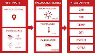
Why do you have to solar map an area?
Solar mapping, also known as solar resource mapping, is the process of assessing the solar energy potential of a particular area by gathering data about the solar resource available at that location. It involves the use of various techniques and technologies to collect and analyze information related to the amount of sunlight received at different times and positions within the target area. Here's a general overview of how solar mapping works:
Data collection: Solar mapping begins with the collection of solar radiation data. This involves the use of ground-based sensors, satellite imagery, or a combination of both. Ground-based sensors measure solar radiation directly, while satellite imagery provides valuable information about cloud cover, atmospheric conditions, and other factors that affect solar radiation.
Instrumentation: Ground-based solar radiation sensors, also known as pyranometers, are typically installed at strategic locations within the target area. These instruments measure the intensity of solar radiation, usually in watts per square meter (W/m²), at regular intervals throughout the day. The sensors may be installed on rooftops, weather stations, or dedicated measurement stations.
Data analysis: The collected solar radiation data is processed and analyzed to generate meaningful information. This involves techniques such as statistical analysis, data interpolation, and modeling. The data is often combined with other meteorological data, such as temperature and humidity, to understand the local climatic conditions that can impact solar energy generation.
Mapping and visualization: The analyzed data is used to create solar resource maps and visualizations. These maps represent the solar energy potential of the target area in a visually understandable format. Different colors or shading indicate the varying levels of solar irradiance across the region. High solar energy potential areas are usually depicted with brighter colors, while low potential areas appear darker.
Interpretation and application: Solar resource maps are utilized for various purposes. They help in identifying suitable locations for solar installations, such as solar farms or rooftop solar panels. Solar developers, urban planners, and energy agencies can use these maps to assess the viability and efficiency of solar energy projects. They can also aid in the estimation of potential energy generation and facilitate decision-making regarding solar energy investments.
Solar mapping techniques can vary depending on the scale and level of detail required. Advanced solar mapping technologies, such as LiDAR (Light Detection and Ranging), can provide highly accurate 3D representations of terrain and shade analysis, enabling even more precise solar potential assessments.
Solar mapping an area is important for several reasons:
Solar energy potential assessment: Solar mapping helps determine the solar energy potential of a specific location. It provides valuable insights into the amount of sunlight available throughout the year, including variations based on seasons and local climate conditions. This information is crucial for estimating the viability and efficiency of solar energy projects.
Site selection for solar installations: Solar mapping aids in identifying optimal locations for solar installations, such as solar farms or rooftop solar panels. By assessing the solar resource at different sites, developers can identify areas with high solar energy potential, minimizing shading from surrounding objects and maximizing energy generation. Solar mapping helps avoid investing in locations that may have limited solar resources, which could result in lower energy production and returns on investment.
Energy production estimation: Solar mapping data, combined with other factors such as the efficiency of solar panels, can be used to estimate the potential energy production of a solar installation. This information is crucial for energy planning, project financing, and evaluating the economic viability of solar projects. It allows stakeholders to make informed decisions about the size and capacity of the solar installations.
Policy and incentive programs: Solar mapping data is valuable for policymakers and energy agencies to develop effective solar energy policies and incentive programs. By understanding the solar potential of an area, governments can create supportive policies that encourage solar energy development. Solar mapping helps identify regions with high solar potential, enabling the targeted deployment of incentives and subsidies to promote clean energy adoption.
Education and awareness: Solar mapping can contribute to raising public awareness about the solar energy potential in a given area. Sharing solar resource maps with the general public, educational institutions, and community organizations helps inform individuals about the benefits and possibilities of solar energy. It can inspire the adoption of renewable energy solutions and encourage community engagement in sustainability initiatives.
Overall, solar mapping plays a vital role in decision-making, project planning, and the promotion of solar energy as a clean and renewable resource. It provides valuable information for various stakeholders, enabling efficient utilization of solar energy and facilitating the transition to a more sustainable energy future.

